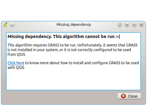
Using the GRASS-commands Toolbox in QGIS 2.8.x LTR on Ubuntu resulted in: “Missing dependency. This algorithm cannot be run 🙁 “. The solution is very simple 🙂
Tipps, Tricks, GIS, Geographical Information Systems, ArcGIS, ArcMap, QGIS
Using the GRASS-commands Toolbox in QGIS 2.8.x LTR on Ubuntu resulted in: “Missing dependency. This algorithm cannot be run 🙁 “. The solution is very simple 🙂
After installing the *.deb from Citrix (in my case 13.2 for x64) you won’t find the PlugIn in the Firefox-PlugIn overview and the receiver is not working – a simple solution that worked for me on 2 different devices.
Citrix receiver 13.2 on Ubuntu with existing older ICA/receiver installed weiterlesen
Mein Problem war es, dass ich in eine Leaflet-Map die “basemap.at”-Grundkarte einbinden wollte.
Hierbei bin ich auf einigen Widerstand gestoßen, denn es gab so gut wie keine Beschreibungen wie man die “basemap.at” als Gurndkarte einzubinden hat.
Doch dank Google-Codesuche hatte ich ein Beispiel gefunden wo genau diese Kombination vorhanden war.
<script src="https://rawgithub.com/mylen/leaflet.TileLayer.WMTS/master/leaflet-tilelayer-wmts.js"></script>
var ign = new L.tileLayer("http://{s}.wien.gv.at/basemap/geolandbasemap/normal/google3857/{z}/{y}/{x}.png", {
subdomains : ['maps', 'maps1', 'maps2', 'maps3', 'maps4'],
attribution: '© <a href="http://basemap.at">Basemap.at</a>, <a href="http://www.isticktoit.net">isticktoit.net</a>'
});
map.addLayer(ign);
Man kann auch die Punkte 2 und 3 in einem Schritt durchführen.
Will man die derzeit verfügbaren anderen “Kartenlayer” von basemap.at einbinden (zB die Orthophotos, Basemap grau,…), so muss man einfach die Tiles-URL in L.tileLayer anpassen – entsprechend den Angaben, die sich im getCapabilities.xml des WMTS-Dienstes finden.
Link-Grundkarte: Basemap.at
Hier ein volles Beispiel mit Basemap & OSM & Blank: Leaflet & Basemap example
Did you ever want to “draw” polygons inverted (masked) with a border with a color gradient ? With QGIS (tested with 2.8) it’s a small step…
Nice QGIS-Symbology feature: inverted polygon with shapeburst weiterlesen
Yesterday I tried to reproduce one of my typical ESRI-workflows with QGIS 2.8.x – having some 2D point-features and converting these features to 3D features deriving elevation from a DEM – and at least I need the z-value in the table… a simple task, or not ?
“3D-features” with QGIS 2.8 – derive elevation from DEM and write into table ? weiterlesen
Bei den Linuxwochen 2015 in Linz stellen wir kurz die Möglichkeiten von OpenSource im GIS-Bereich vor. Ein 45min Überblick zu GIS und speziell QGIS und OpenGeoData.
Die eigene Karte mit OpenSource & OpenData – @Linuxwochen Linz 2015 weiterlesen
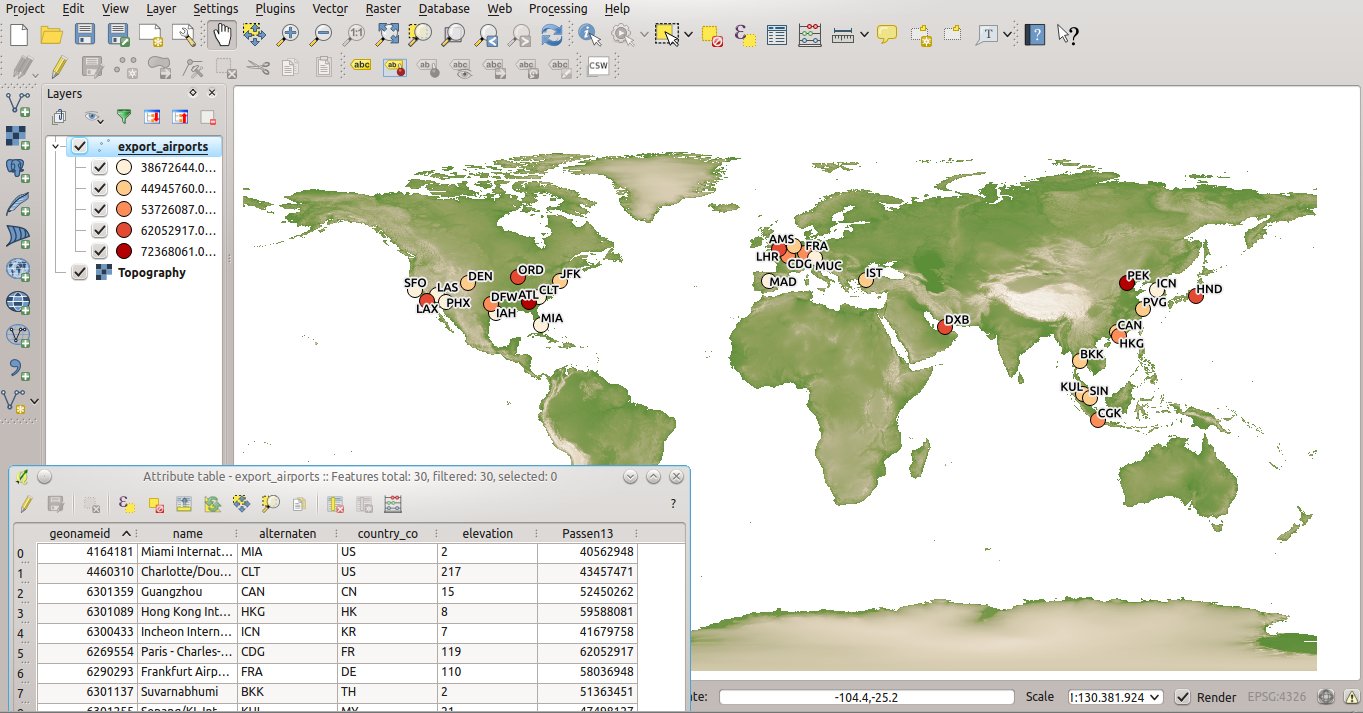
Shapefile Top30 airports 2013 and 2014 with passenger numbers as an attribute – Downloads
QGIS 2.8.0 had some show-stopper problems using WMTS-services like basemap.at (e.g. issues 12241 and 12244)Some days later QGIS 2.8.1. was released and WMTS works fine – sometimes with 1-2 additional clicks… & enjoy the new aerial image service for Austria !
QGIS 2.8.0 and 2.8.1 – WMTS probs with basemap.at weiterlesen
Last week i enjoyed some business news about the worlds largest airports in number of passengers. I followed a link to the official statistics and as a GIS-Nerd the idea was born: A geodataset would be nice…
Shapefile Top30 airports worldwide with passenger-numbers 2013 weiterlesen
Gestern bin ich bei der Verwendung der basemap.at, einem sehr nützlichen WMTS-Dienst mit einer freien Grundkarte Österreichs, über einige interessante Neuerungen im Dienst gestolpert: eine neue “graue Grundkarte” und eine high-DPI-Variante der bestehenden basemap.at.
Österreich in “grau” und “highDPI” – neue Varianten der basemap.at weiterlesen